
CPaCE News
Grad's High-Tech Tree Maps Show a Green and Healthy Campus

As a Geographic Information Science (GIS) Analyst for West Coast Arborists, Andrew Pineda has had his eyes trained on green space in California. The family-owned company provides professional tree maintenance and management services including tree planting and pruning as well as maintaining an inventory of trees using global positioning system (GPS). Wanting to learn even more about how GIS could inform our understanding of the environment, Andrew enrolled in CSULB’s Master of Science in Geographic Information Science (MSGISci) degree program.
From September 2020 to August 2021, the MSGISci program’s flexible schedule of classes on weekday afternoons and Saturdays allowed Andrew to continue working full-time while absorbing a comprehensive curriculum of GIS topics. These included cartography design and related technology like drones and remote sensing. While attending classes mostly online during the pandemic, a field trip to River Ridge Ranch offered an important opportunity for Andrew to interact with MSGISci classmates outdoors, as they experimented with the latest mapping techniques to support ecological preservation in the western Sierra Nevada foothills.
“What I learned throughout the course of the program has helped me bring new ideas and workflows to my workplace, which have helped increase performance and offerings all around,” he said.
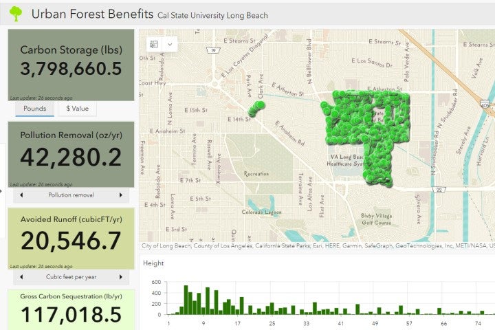
With all this new knowledge and experience under his belt, Andrew began to develop a unique website featuring multiple interactive maps that quantify the environmental benefits of trees within the CSULB campus. Counting more than 7,000 trees that represent 183 distinct species, the case study identifies multiple related benefits—from positive impacts on human health to an increase in economic property values.
Andrew soon began racking up numerous awards for this groundbreaking work, both during and immediately after the MSGISci program. He earned first place in the Interactive/Digital category of the David Woodward Digital Map Award, part of an annual mapmaking competition created by the Cartography and Geographic Information Society, which included $500 and state-of-the-art Avenza MAPublisher GIS software. Andrew’s other honors have included:
- ESRI 2021 UC Gallery and Gallery Awards 2nd place in the 3D Map category
- ESRI 2021 UC Gallery and Gallery Awards 3rd place in the Student Map - Post-Secondary category
- URISA Vanguard Cabinet - Digital Competition 2nd Place Student and Young Professional Digital Competition
- International Cartographic Exhibition ICE 2021
“I plan to be a lifelong student of GIS,” Andrew said, “and continue to learn and grow with the field. I plan on searching out more opportunities that can help expand my knowledge.”
Click here to learn more about the MSGISci program at CSULB.
More Alumni Profiles More Community Outreach More Student Profiles